Stephen M. Strader, Ph.D.
Associate Professor
Graduate Program Director
Department of Geography and the Environment
College of Liberal Arts and Science
Villanova University


Disasters are a product of society and are caused by extreme events interacting with human, social, and physical vulnerabilities


Research
My research: 1) Uncovering the fine-scale relationships between tornado fatalities, manufactured housing, and societal vulnerability
2) Assessing severe hail impacts on the built and agricultural landscape 3) Examining the geospatial relationships between tropical cyclone hazards, societal vulnerability, resilience, and mortality
Tornado risk has exhibited robust spatial trends in the United States Southern Plains and Mid-South during recent decades. The consequences of these risk changes have not been fully explored, especially in conjunction with growing societal vulnerability. Herein, we assess how changes in risk and vulnerability over the last 40 years have collectively and individually altered tornado-housing impact potential. Results indicate that escalating vulnerability and exposure have outweighed the effects of spatially changing risk. However, the combination of increasing risk and exposure has led to a threefold increase in Mid-South housing exposure since 1980. Though Southern Plains tornado risk has decreased since 1980, amplifying exposure has led to more than a 50% increase in mean annual tornado-housing impact potential across the region. Stakeholders should use these findings to develop more holistic mitigation and resilience-building strategies that consider a dynamically changing tornado disaster landscape.


During the evening and overnight hours on 2-3 March 2020, a supercell traveling at 26 ms-1 (65 mph) across Tennessee produced several significant (EF2+) tornadoes. The tornadoes resulted in 25 fatalities and over 100 injuries, with most deaths occurring in the EF4 Cookeville, TN tornado. Approximately 18 months later (10 December 2021), a devastating, cool-season tornado outbreak produced many intense tornadoes under the cover of darkness, including a long-track, 265 km (165 mi), EF4 tornado that killed more than 50 people in Kentucky. Unfortunately, these fatal nocturnal tornado events—i.e., tornadoes that occur in the period from sunset to sunrise—are not uncommon in the Ohio River and Tennessee Valleys and are a factor in this region’s particularly high tornado mortality. No matter the region, Nocturnal tornado events lead to vulnerability and mitigation issues that reduce warning and sheltering efficacy; those issues, in turn, lead to disproportionate—in comparison to their daytime counterparts—casualty rates . For this reason, NT tornado risk, and the vulnerabilities it produces, needs further study.

Mobile & manufactured housing (MH) residents are the most tornado vulnerable subset of the population due to a combination of physical and socioeconomic factors. Despite the weather and emergency management enterprises consistently suggesting that MH residents evacuate their homes for sturdier shelter during tornado events, more than 50% of MH residents believe their homes are safe sheltering locations. In addition, although the U.S. Department of Housing and Urban Development (HUD) indicate that improvements in building codes in 1976 have rendered MHs as wind resistant/safe as permanent homes during tornado events, research continues to illustrate MHs are FAR LESS safe during severe wind events compared to permanent homes. Overall, the Southeast U.S. contains the greatest tornado-vulnerable population in the U.S. due to the combined effects of a larger number of MHs and more sprawling development pattern. Other vulnerability factors include: greater socioeconomic vulnerability, a lack of adequate sheltering options, lower self-efficacy during tornado events, etc. (See Publications in the Abridged C.V.)

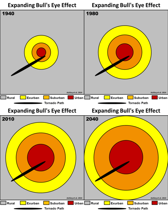
What is the expanding bull's eye effect? “Targets”—i.e., humans and their possessions—of geophysical hazards are enlarging as populations grow and spread. It is not solely the population magnitude that is important in creating disaster potential, it is how the population and built environment are distributed across the landscape that defines how the fundamental components of risk and vulnerability are realized in a disaster.
Why is it important? While climate change may amplify the risk of certain hazards, the root cause of escalating disasters is not necessarily event frequency, or risk, related. Rather, our recent research confirms the upward trend in disasters is predicated on increasing exposure and vulnerability of populations.
(See this site for greater explanation and related publications)
